Maximum 6 Walkers 7 Nights - 5 Walking Days
From €849.00
On our way to the Saltillo waterfalls

Join us for a unique journey through Axarquía.

Axarquía is a wedge-shaped area located to the east of Malaga, consisting of 31 municipalities. Its name originates from Arabic and means 'the eastern'. It is one of the sunniest places in mainland Spain, with an average of 320 sunny days per year. The region is bordered by mountains inland and along the coastal towns.

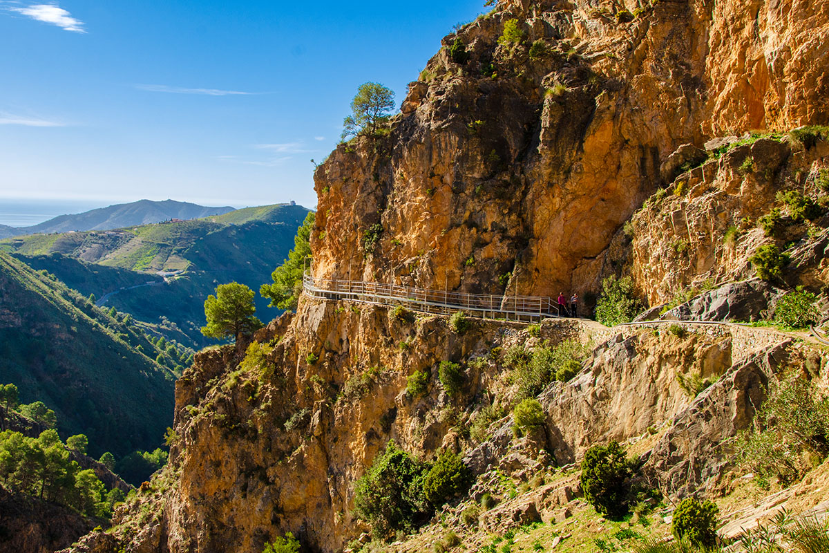
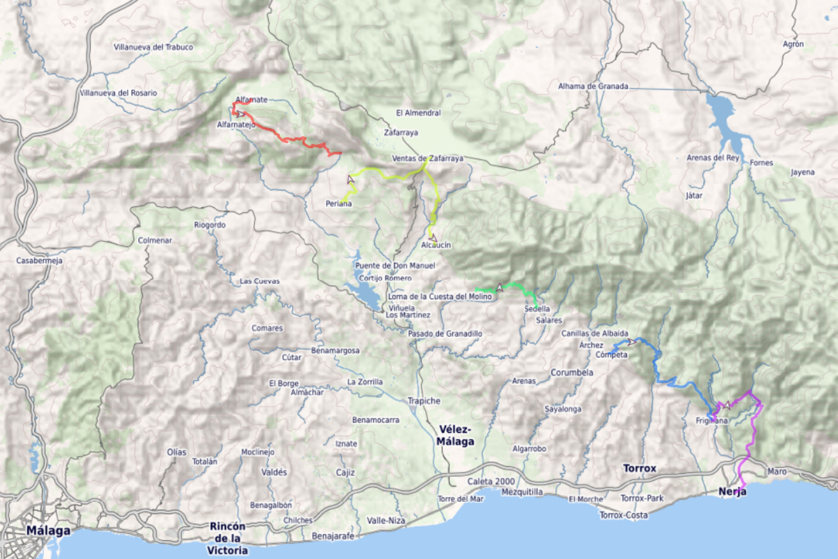
During our journey, we will travel below the mountains of the Central Limestone Arch and towards the lower slopes of the Tejeda and Almijara Natural Park on the eastern side of Axarquia. Along the way, we will pass through several towns and villages, enjoy breathtaking panoramic views, cross the Almanchares Barranco, and learn about the history and culture of this unique area of Malaga.

We have arranged for you to stay in two excellent hotels, which helps to reduce travel time for the walks. From Saturday to Wednesday, you will stay at Hotel Arcos del Sol, adjacent to the inland town of Colmenar. After a short transfer to the coast, you will move to Hotel Marissal in the coastal town of Nerja and stay there until your departure on Saturday.

How difficult?

The walks are not designed to be challenging, and although we will have some long distances, this holiday should be comfortable for regular walkers who are used to longer days in the hills, with rough ground underfoot and longer ascents. We have rated the walks as moderate, with some sections rated strenuous.

When we set out each day, our walks are between 12 and 19 kilometres, with approximately 550 to 1000 metres of ascent.

When to come.

This holiday is only available in October each year. However, if you are looking to book for a group of four to six, we can offer this holiday on alternative dates in April, October, and November. Contact us for more information.

The weather is generally consistent in those months, allowing you to enjoy this unique walking holiday.

Our photo album has great pictures from this walking week, and if you want to know more about what you will see on the walks, read our Blog article. 

Availability and Price

2025 Dates 18th to 25th October
4 Spaces Available  
€849 per person Two sharing
€949 per person Single room


Nearest Airport
Malaga (AGP) 40 min transfer time
Arrival
Saturday
Departure
Saturday
Included
  • Accommodation
  • Guide
  • Transport
  • Breakfast
  • Packed Lunch
  • Free airport transfer
Not Included
  • Flights
  • Airport Taxi (if not able to use our free service)
  • Evening Meal
Arrival

We offer free collection from Malaga airport and run two journeys on the arrival day. We try to operate these with your flight times and generally have a mid-morning and mid-afternoon collection.

If you cannot join us on one of our collections, then there are taxis that operate from Malaga Airport to Colmenar.

If possible then we do like to meet up for a tapas and drinks in the afternoon so that everyone can get to know each other, and we can run through the itinerary for the week.

A day in the mountains

Alfarnate, a typical Andalucian mountain village with narrow streets and white-painted houses, sits between the long and sweeping mountains of the Central Limestone Arch and at the base of the Sierra de Enmedio.

It is the start of our walk today to the summit plateau of Pico del Vilo. 

Sierra de Enmedio, of which the Pico del Vilo is its highest point, has a different orientation to the other mountains in the area, sweeping northwest to southeast instead of west to east, and with the reforestation that has occurred on the higher slopes, our way through this rocky landscape gives interesting views as we make our way higher.

Upon arrival at the summit plateau, we are at the very geographical top of the Axarquia region, with the whole region visible below us. To our north is the 'wall' of the Central Limestone Arch, with the highest point of the 50km mountain chain, Chamizo, dominating our near-horizon.

On a clear day, we are blessed to see the summit, probably snow-capped, of Pico del Veleta, the highest mountain in mainland Spain, and La Tiñosa, the highest mountain in Cordoba.

A truly magnificent start to this walking adventure.

Highlights of the walk include.

Refreshments at the beginning of the day in Alfarnate

A visual perspective of the Central Limestone Arch

Walking through the pine forests

Discovering the interesting karst limestone formations of the mountain

Expansive views towards Granada and Cordoba

Tapas/refreshments in the village of Guaro

Max travel time: 30 mins

Distance: 16 kilometres

Ascent: 680 metres

Walk Duration: 7 to 8 hours

Following the Railway Line

To the southeast of Alfarante, just across the border into the Province of Granada, and at the top of the mountain pass, is Llano de Zafarraya (Zafarraya Meadow). 

A prime grazing area for centuries, these fertile lands now grow many out-of-season vegetables. 

Access to Zafarraya was possible only by a torturous mountain pass, a track that climbed from the valley below and cut through a natural break in the mountain. Humans have used this pass for millennia, with Neolithic remnants found in the caves at the top. During the long Moorish occupation, this pass was known as the Nasrid Road, guarded by Zalia Castle on the lower slopes.

To improve access to Zafarraya and open up trade to the cities of Malaga and Granada, a narrow-gauge railway line was constructed in the early 1900s.

Planned to link Malaga, Velez-Malaga, Perriana, and Zafarraya, this ambitious construction project saw an impressive track cut along the base of the mountains above Perriana towards Zafarraya.

The railway eventually reached Zafarraya in 1922 but never reached Granada and closed in 1960. The old station hotel, built in 1920 by a Belgian architect in the style of an alpine chalet, is now a cafe bar and is on our route today.

The whole railway line is now disused and makes for a fantastic trail linking the towns of Periana and Ventas de Zafarraya, culminating at the head of the Pass of Zafarraya.

Highlights of the walk include.

Refreshments at the beginning of the day in Periana

Expansive views south into Axarquia

Walking along the disused railway line, over and under the bridges, and through the tunnel

Arriving at the top of the Pass of Zafarraya

Refreshments in the old railway station at Zafarraya

The final section of the walk through a very scenic path to Alcaucin

Tapas/refreshments in Alcaucin

Max travel time: 30 mins

Distance: 19 kilometres

Ascent: 570 metres

Walk Duration: 6 to 7 hours

Crossing the Almanchares Gorge

The mountain La Maroma dominates the eastern skyline of Axarquia, and at 2069 metres, it is the highest point in the Malaga Province. It forms part of the Tejeda Natural Park. The western and southern faces of the mountain drop precipitously into the Axarquia region, and between the barrancos are several picturesque villages.

One very popular path on the lower slopes of La Maroma is the Senda de Saltillo. Rising out from the village of Canillas de Aceituno, it follows along the route of the aqueducts to arrive at the pools of Saltillo at the upper reaches of the Almanchares Gorge. 

In 2021, with the completion of a 50-metre-long suspension bridge, the third longest in the natural areas of Spain, over the Almanchares Gorge, the Senda de Saltillo path can now be extended to the village of Sedella. 

Referred to as the 'Caminto del Rey of Axarquia', this walk combines unending panoramic views with an exciting bridge crossing and an exhilarating climb out from the gorge. The Almanchares Gorge is also home to varied flora and fauna and, if we are lucky, a sighting of the Southern Spanish Ibex.

The bridge crossing is very safe, although the path that climbs up from the bridge to regain the forestry track is exposed. The path is secure, it has reasonable steps cut into the rock, and chains are installed into the rockface where required to assist with the ascent. Nothing is challenging about the path except that some sections are exposed to the gorge below. 

Highlights of the walk include.

Refreshments at the beginning of the day in Canillas de Aceituno

Walking along the Aqueducts 

Following the Almanchares Gorge to the Saltillo pools

The suspension bridge across the Almanchares Gorge

Stopping at the Los Pozuelos Mirador

Refreshments/Tapas in Sedella

Max travel time: 45 mins

Distance: 12 kilometres

Ascent: 550 metres

Walk Duration: 5 to 6 hours

You'll be staying in Nerja for the second part of the Axar Trail.

You can use this as a rest day, but with many attractions close to Nerja, we can arrange something different for you to do.

The world-famous Caves of Nerja are close to the hotel, and at Burriana Beach, there is the opportunity to sunbathe, enjoy a paella in one of the churinguitos, or rent a kayak or paddleboard and explore the coastline.

Transfer travel time: 55 mins

Finding the 'Lost Village'

The hamlet of El Acebuchal was an important staging post on the ancient mule-trading routes between Competa, Frigiliana, and Nerja. Produce from the coast was traded for goods not readily available in the nearby mountains.

Unfortunately for the inhabitants of this village, they became embroiled in the fight between the Franco regime and the guerrillas in the aftermath of the Spanish Civil War. Suspected of supporting the rebels that were hiding in the mountains, in 1948, the villagers were forced to flee the village when the Guardi Civil ordered that the village be cleared.

The abandoned mountain hamlet soon fell into disrepair and eventually into ruins, known locally as "The Lost Village".

Fifty years later, descendants of one of the original villagers returned to restore a couple of houses in the village. Once these were completed, other houses and the tavern were rebuilt, and tourism increased.

Acebuchal was returning to life. With the remaining houses and chapel restored, Acebuchal is now a charming and picturesque hamlet and the focus of today's walk.

We start in the mountain town of Competa, and after an invigorating climb into the Sierra de Almijara Natural Park, we connect up with the old mule track to Acebucahl. 

Highlights of the walk include.

Refreshments at the beginning of the day in Competa

Walking in the Sierra de Almijara Natural Park

Expansive views of the coast and natural park

Refreshments in Acebuchal

Finish the walk in the white-village of Frigiliana

Max travel time: 40 mins

Distance: 18 kilometres

Ascent: 1000 metres

Walk Duration: 7 to 8 hours

Crossing the Rio Chillar

For our final day from this series of walks, we return to the Sierra de Almijara and delve deeper into this natural park. The mountains here are more dramatic, with barrancos between pine-covered ridges, dramatic rockfaces, and alpine-like peaks; it is a beautiful place to end our exploration of Axarquia.

We start our walk in the village of Frigiliana, make our way up onto the southern slopes of the Sierra de Almijara, and contour around to meet the Rio Chillar. The source of the Rio Chillar starts high up in the Sierra de Almijara and runs continuously to the sea.

When we reach the Rio Chillar, we'll stop under the shade of the Pine trees and enjoy the tranquillity of this tiny oasis.

We leave the natural park by following the aqueduct that draws water from the Rio Chillar, and as the gorge beneath us drops away, we make our final ascent to join our path back to Nerja.

Highlights of the walk include.

Refreshments at the beginning of the day in Frigiliana

Walking in the Sierra de Almijara Natural Park

Stopping at the Rio Chillar

Walking beside the Aqueduct

The descent at the end of the day to Nerja

Tapas/refreshments at Burriana Beach in Nerja

Max travel time: 15 mins

Distance: 17 kilometres

Ascent: 875 metres

Walk Duration: 7 to 8 hours

We offer a free return to Malaga airport and run two journeys on your departure day. We try to operate these with your flight times and generally have a mid-morning and mid-afternoon return.

If you cannot join us on one of our return journeys, we can arrange for a taxi to collect you from the hotel and take you to Malaga Airport.